Introduction
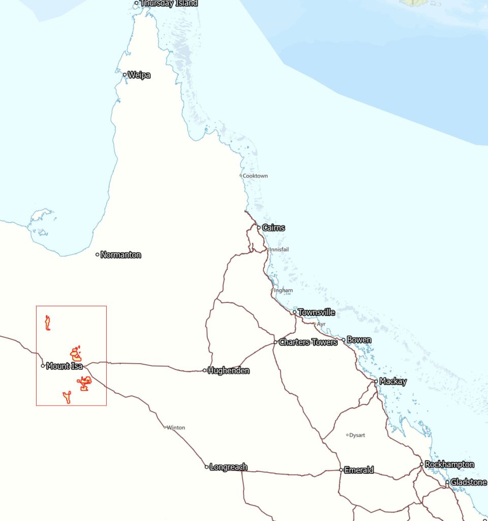
Coppermoly has significantly grown its exploration portfolio in the Mount Isa Inlier, one of the most prospective terrains for copper gold deposits in the world. As of November 2024, the Company’s Mt Isa projects include four granted tenements and four applied tenements, all within a short distance to some of Australia’s largest producing copper assets including the world-famous Ernest Henry discovery.
Location
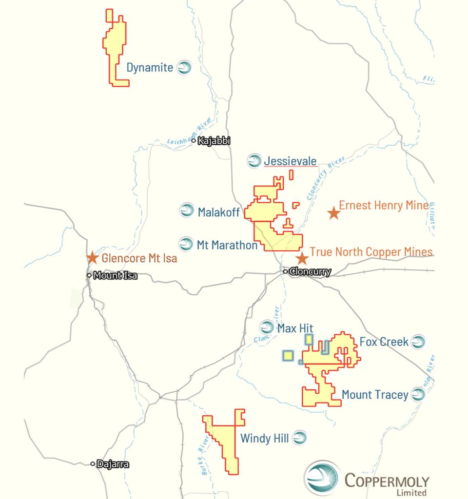
Tenements
| Exploration Permit | Area | Location |
|---|---|---|
| EPM 27835 Fox Creek | 320 km² | Mt Isa, Queensland |
| EPM 27836 Mount Tracey | 294 km² | Mt Isa, Queensland |
| EPM 28751 Windy Hill | 320 km² | Mt Isa, Queensland |
| EPM 28853 Malakoff | 305 km² | Mt Isa, Queensland |
| Applied Exploration Permits | ||
|---|---|---|
| EPM 28854 Mt Marathon | 310 km² | Mt Isa, Queensland |
| EPM 28981 Dynamite | 307 km² | Mt Isa, Queensland |
| EPM 29002 Jessievale | 35.5 km² | Mt Isa, Queensland |
| EPM 29102 Max Hit | 64.3 km² | Mt Isa, Queensland |
Geology
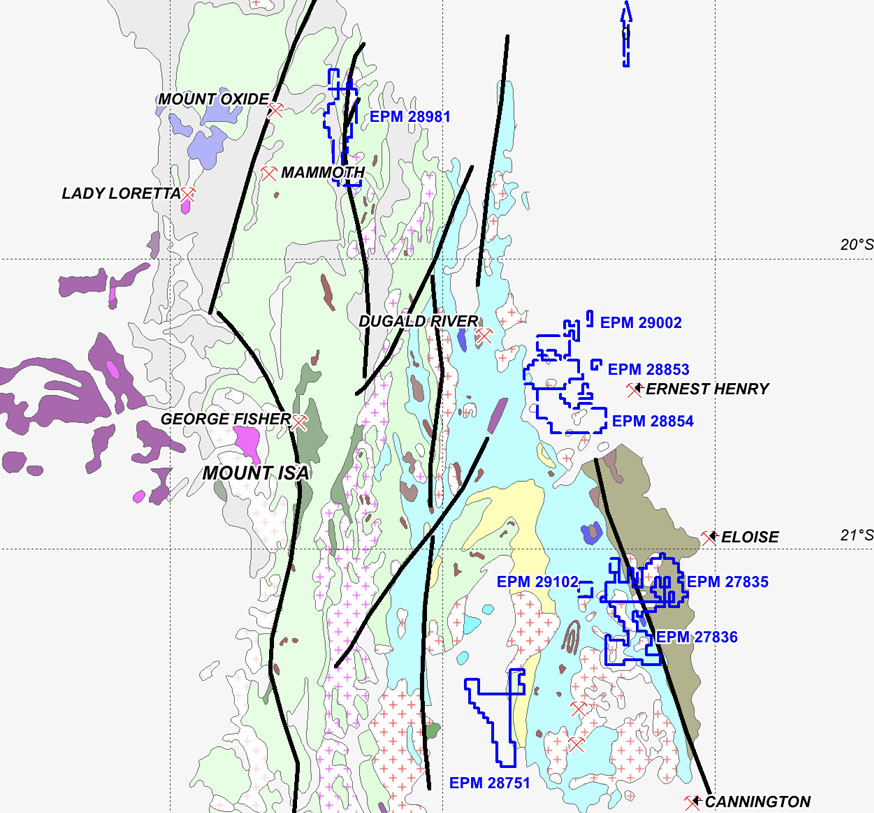
Six of the tenements with high-quality IOCG potential are located within the Eastern Succession and one for an Isa style copper system sits in the Western Foldbelt (Fig 1).
All seven tenements are 100% owned (subject to pending applications) by the Company (see Tenements above).
The district has a long history of copper production.
The Mount Isa Ore body has been producing for over 90 years and is believed to have held 300Mt @ ~3% Cu and 395 Mt zinc-lead-silver at ~6.9% zinc, ~3.6% lead, and ~69 g/t silver.
Our Projects
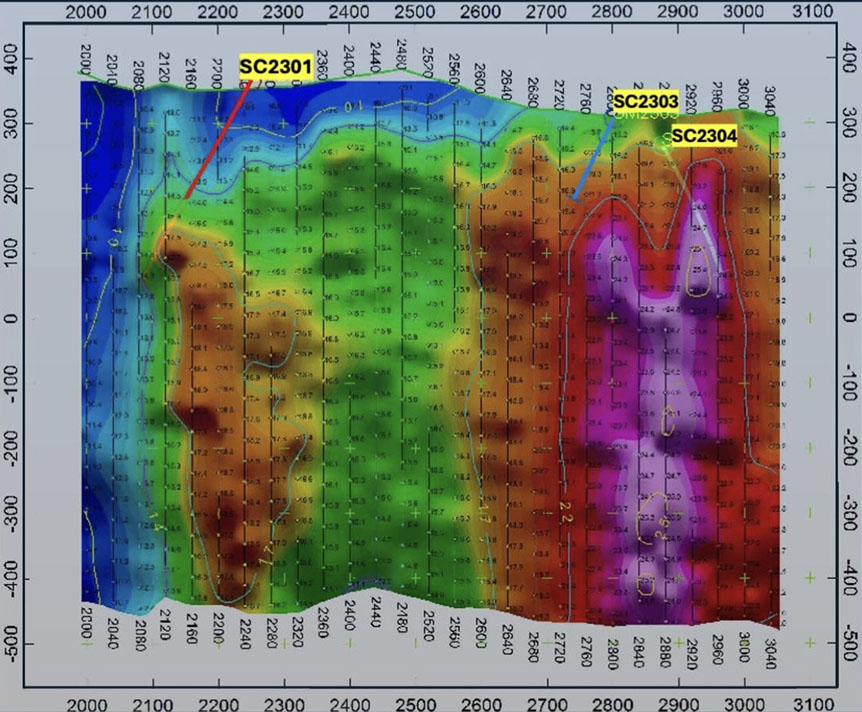
Shuffleton Prospect (Mount Tracey EPM 27836)
Following the test drilling program in the last quarter at the Shuffleton Prospect, remodeling the IP Sounding profiles and reassessing drilling data, the company is planning to complete additional 4 holes previously proposed and budgeted for as soon as a drill rig can be mobilized to the site (Fig 2).
Windy Hill Prospect – EPM 28751
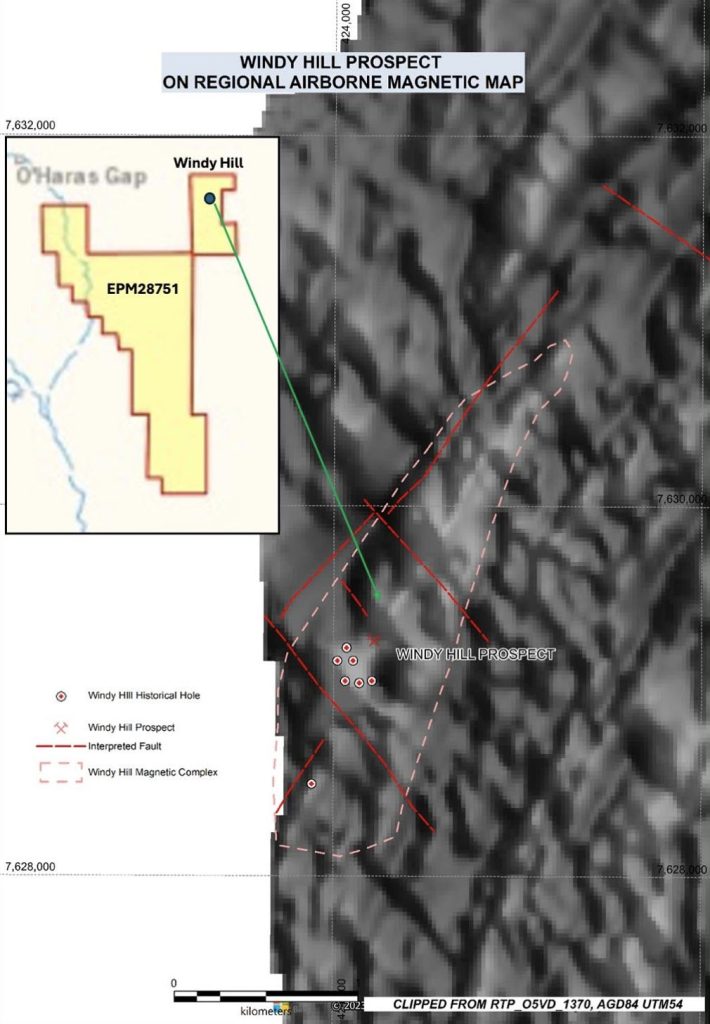
Windy Hill Prospect is located approximately 80 kilometres south-west of Cloncurry.
The Windy Hill prospect, initially located by CRAE, is a mineralized breccia within Argylla Formation rhyodacite volcanics. Gossanous zones associated with quartz veining occur in the immediate vicinity of the Windy Hill breccia.
The area selected was thought to have good potential for copper-gold and gold mineralisations associated and magnetite concentrations, as observed at the Ernest Henry and Osborne deposits. Contacts with the 1500 Ma Wimberu Granite are thought to be prospective for this type of mineralisations system.
Late airborne magnetic survey, covering part of the tenement, reveals that the Windy Hill magnetic high complex extends over 2 km to the NNE, and CRAE and MIME ‘s works covered a small section of the Windy Hill magnetic complex (Fig. 3). The company will reprocess geophysical data and propose new survey covering the whole breccia zone as soon as practical.
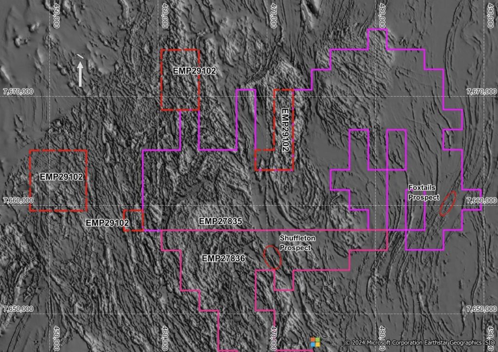
Max Hit Prospect – EPM 29102
This new application is adjacent to existing tenements along the Cloncurry Fault Zone (Figure 4 – shown in red).
The tenement covers about 63 sqkm of Staveley/Doherty/Corella formation with greatly brecceias and alterations reported.
Some small historical copper works are recorded, iron/quartz breccias zones extend over several kilometers. This tenement is considered to be a natural extension of the south Cloncurry tenements group.
Malakoff Prospect – EPM 28853
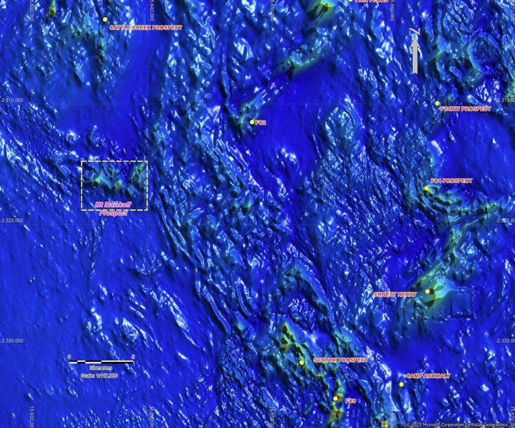
The Mt Malakoff Prospect is about 30 km WWN of the famous Ernest Henry Mine. Both magnetic IOCG (iron- oxide copper gold) models and ISCG (iron-sulphide copper-gold) models will be utilised over the project area.
Drill hole geological and downhole geophysical logs provide some basement information for geophysical typing, geological interpretation. Recent high resolution aeromagnetic data can be used to scan large scale IOCG targets similar to Ernest Henry Cu-Au system (Fig. 6).
Mt Malakoff Prospect covers several magnetic anomalies under a very thin 10-50m Tertiary sediments. One of those anomalies is particularly interesting, which is a roughly 5 km x 3 km Southeast-Northwest cluster of several irregularly shaped, very high amplitude (> top 1% of data range) magnetic anomalies located northeast of the Naraku Granite. The style of possible alteration and precursor rock types evident in the basement drill hole data at the magnetic complex is very similar to that which occurs at Ernest Henry located roughly 30 km to the ESE (Fig 9).
Dynamite Prospect – EPM 28981
The Dynamite Project sits about 130 km north of Mount Isa and 25 km east of the Mount Oxide Copper Deposit. There are two historical copperworks in Fearnot and Dynamite. Previous reports describe that copper mineralisation can be traced discontinuously for several kilometres north and south of Dynamite Creek along the major Quilalar Fault corridor. The Quilalar Fault strikes northsouth, forming the east boundary of the Bull Creek Syncline which extends for over 90km from the Crystal Creek Block in the far south to the far north where sediments of the Mesozoic Carpentaria Basin cover the Proterozoic geology. Several significant northeast faults including the Investigator and Mammoth extended faults continue into the Bull Creek Syncline area.
The project area has been covered by detailed airborne magnetic, electromagnetic surveys, which highlight significant rock-fluid alteration domains containing known copper mineralisations Fearnot and Dynamite copper works (Fig 10).
